2.5: Activity 2D- Latitude and Longitude

GEOS: A Physical Geology Lab Manual for California Community Colleges · LibreTexts

0%

Contents

    Text

    Size
    100%
    Theme
    Typeface
    Line length
    Spacing

    Read aloud

    How

    Speed: 1×
    Light up
    Highlight

    Symbols: Mulberry Symbols, © 2018–2026 Steve Lee, CC BY-SA 4.0 (licence, the set), the site's own copies.

    From LibreTexts, under CC BY-SA 4.0, as the source states it; its equations are written in TeX, which the PDF shows typeset. This page at LibreTexts.

    2.5: Activity 2D- Latitude and Longitude
    1. On Figure 2.24 below, identify and label (at A-D) the following lines of latitude: South Pole, North Pole, Tropic of Cancer, Tropic of Capricorn, Equator
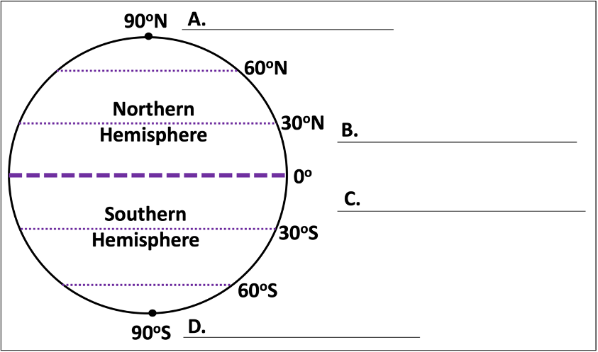
    Figure 2.24, image to label lines of latitude at A, B, C and D.
    Figure 2.24: Label the lines of latitude indicated at A, B, C and D.

    On Figure 2.25 below, label the meridian highlighted at A.

    Is this a line of latitude or longitude?

    Figure 2.25, image to label the lines of longitude at A.
    Figure 2.25: Label the major line of longitude indicated at A.

    Attributions

    • Figure 2.24: “Latitude Activity” (CC-BY 4.0; Chloe Branciforte and Cynthia Lampe, own work)
    • Figure 2.25: “Longitude Activity” (CC-BY 4.0; Chloe Branciforte and Cynthia Lampe, own work)

    This page titled 2.5: Activity 2D- Latitude and Longitude was last modified on Fri, 06 May 2022 23:34:16 GMT and is shared under a CC BY-SA 4.0 license and was authored, remixed, and/or curated by Chloe Branciforte and Emily Haddad (ASCCC Open Educational Resources Initiative) .