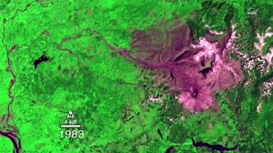
Landsat Tracks Mount St. Helens Recovery
NASA Goddard Space Flight Center
ScienceSpace
Clips are not offered for this film: NASA's media guidelines set the terms of its reuse themselves, not as a public licence.
Parts
About
The May 18, 1980, eruption of Mount St. Helens came after two months of small earthquakes. During the eruption, an avalanche of debris and mud spread for miles from the former summit, and a blast of steam and hot ash covered an area of about 600 square kilometers (230 square miles). In the decades since, scientists have studied the recovery of the ecosystem around the mountain using the Landsat series of satellites. By observing different wavelengths of light reflected of the surface, Landsat data can identify different types of landcover. This visualization uses red, near-infrared, and green to distinguish healthy vegetation (green) from bare ground (magenta). NASA and the U.S. Department of the Interior through the U.S. Geological Survey (USGS) jointly manage Landsat, and the USGS preserves a 40-plus-year archive of Landsat images that is freely available over the Internet. Since the launch of Landsat 1 in 1972, Landsat satellites have become an integral part of many operational land management activities. Landsat satellites provide decision makers with key information about the world’s food, forests, water and how these and other land resources are being used.
Human-made No record of this work says a model made it. What this means.
- Archive
- NASA Image and Video Library, in NASA
- Licence or status
- NASA media guidelines, as the NASA Image and Video Library states it.
- Credit
- NASA Goddard Space Flight Center
- Language
- English
- Country
- United States
- Subtitles
- English
- Who can watch
- The archive gives no rating. Invisible Network shows it to Tweens profiles and older, judged from its collection and subjects. How films are placed
More from NASA
 Film
Expedition 65 JAXA PAO Event
 Film
GPM Instrument Animations
 Film
An EPIC View of the 2017 Total Solar Eclipse
 Film
Can You Spot Hubble: Long
 Film
Predicting Malaria Outbreaks with NASA Satellites
 Commercial
Launching America On a Commercial Spacecraft on This Week @NASA – June 5, 2020
 Film
NASA joins last of five sections for Space Launch System Rocket stage
 Film
Science Launching on SpaceX's 30th Cargo Resupply Mission to the Space Station
 Film
Jessica Meir Speaks with Physiologist Magazine
 Film
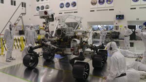
Video File: Launch of NASA’s Next Mars Rover Perseverance Approaches
 Film
Expedition 63 HTV 9 Release
 Film