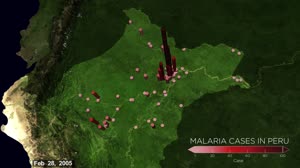
Predicting Malaria Outbreaks with NASA Satellites
NASA Goddard Space Flight Center
ScienceSpace
Clips are not offered for this film: NASA's media guidelines set the terms of its reuse themselves, not as a public licence.
Parts
About
In the Amazon Rainforest, few animals are as dangerous to humans as mosquitos that transmit malaria. The tropical disease can bring on severe fever, headaches and chills and is particularly severe for children and the elderly and can cause complications for pregnant women. In rainforest-covered Peru the number of malaria cases has spiked such that, in the past five years, it has had on average the second highest rate in the South American continent. In 2014 and 2015 there were 65,000 reported cases in the country. Containing malaria outbreaks is challenging because it is difficult to figure out where people are contracting the disease. As a result, resources such as insecticide-treated bed nets and indoor sprays are often deployed to areas where few people are getting infected, allowing the outbreak to grow. To tackle this problem, university researchers have turned to data from NASA’s fleet of Earth-observing satellites, which are able to track the types of human and environmental events that typically precede an outbreak. With funding from NASA’s Applied Sciences Program, they are working in partnership with the Peruvian government to develop a system that uses satellite and other data to help forecast outbreaks at the household level months in advance and prevent outbreaks.
- Archive
- NASA Image and Video Library, in NASA
- Licence or status
- NASA media guidelines, as the NASA Image and Video Library states it.
- Credit
- NASA Goddard Space Flight Center
- Language
- English
- Country
- United States
- Subtitles
- English
- Who can watch
- The archive gives no rating. Invisible Network shows it to Tweens profiles and older, judged from its collection and subjects. How films are placed
More from NASA
 Film
Expedition 65 JAXA PAO Event
 Film
GPM Instrument Animations
 Film
An EPIC View of the 2017 Total Solar Eclipse
 Film
Can You Spot Hubble: Long
 Commercial
Launching America On a Commercial Spacecraft on This Week @NASA – June 5, 2020
 Film
NASA joins last of five sections for Space Launch System Rocket stage
 Film
Science Launching on SpaceX's 30th Cargo Resupply Mission to the Space Station
 Film
Jessica Meir Speaks with Physiologist Magazine
 Film
Video File: Launch of NASA’s Next Mars Rover Perseverance Approaches
 Film
Expedition 63 HTV 9 Release
 Film
Recientemente: El presidente solicita presupuesto para la NASA - 17/03/23
 Film