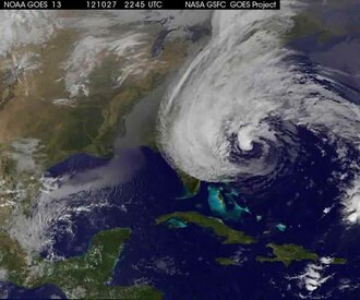
Hurricane sandy nasa satelite time lapse video
NASA GOES-13 program
Space
Make a clip
Public domain · NASA GOES-13 program
Up to 60 seconds, at most the picture size of the copy it is cut from. The clip carries the title, the credit, the licence and a link back here. It is made in this browser, and nothing is sent to this site.
Or send the moment itself: https://invisiblenetwork.ai/watch/archive/commons/22553575?play=1&t=0
Parts
About
This is a time-lapse video made from NASA satellite images of hurricane Sandy. Hurricane Sandy drifted up along the Gulf Stream from the Caribbean to the mid-Atlantic to become wedged between a stationary cold front over the Appalachians and a static high pressure air mass over maritime Canada. The Canadian air mass blocked the storm from moving farther northeast. Instead, the easterly winds circulating around the south side of the Canadian high amplified Sandy and drove it westward into the mid-Atlantic states. Sandy became a ferocious "Nor-easter" that brought record storm surges to coastal New Jersey and New York, and the cold front caused blizzard conditions along the Southern mountains. The storm surget at high tide created unprecedented chaos in New York City, such as darkening lower Manhattan and flooding the subway system on the evening of 29 October.
Human-made No record of this work says a model made it. What this means.
- Archive
- Wikimedia Commons, in Wikimedia Commons
- Licence or status
- Public domain, as the Wikimedia Commons states it.
- Rights statement
- Public domain
- Credit
- NASA GOES-13 program
- Who can watch
- The archive gives no rating. Invisible Network shows it to Tweens profiles and older, judged from its collection and subjects. How films are placed
More from Wikimedia Commons
 Short
Curiosity's Seven Minutes of Terror
 Short
Launch Recap NASA and SpaceX fly Astronauts to the Space Station
 Short
Space Station Live - Cultivating Plant Growth in Space
 Short
STS-132 Liftoff Space Shuttle Atlantis
 Short
Narrated Distributed Water Balance of the Nile Basin
 Short
Moon Phase and Libration, 2020 South Up 4K UHD
 Short
NASA's Mars 2020 Perseverance Rover Landing Animations-rzmd7RouGrM
 Short
Alexander Gerst’s Earth timelapses (2017 reissue)
 Feature
Restored Apollo 11 Moonwalk - Original NASA EVA Mission Video - Walking on the Moon
 Short
First 8K Video from Space - Ultra HD VP9
 Short
Orion Camera View of Artemis II Climb to Orbit (art002m1200912237)
 Short